
Electrical Resistivity
Electrical conductivity and resistivity measurements provide valuable information about the subsurface properties of materials, helping professionals make informed decisions in a wide range of applications, from environmental assessments and resource exploration to civil engineering and archeology.
Summit's geophysical professionals utilize a wide variety of field applications, including:
- Identify near surface geologic and hydrogeologic features
- Bedrock surface, clay layers, cavities/sinkholes/voids, karstic features, depth to groundwater, and possible contaminant presence
- Property/infrastructure development
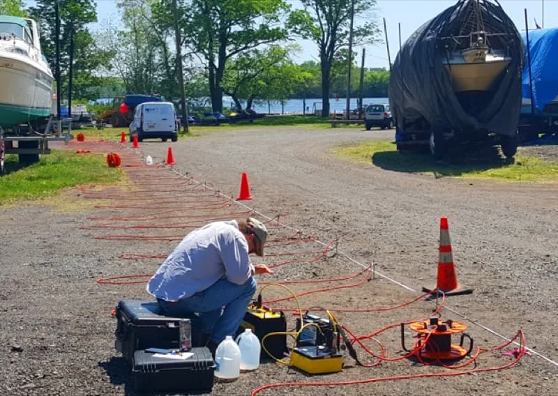
Electrical Resistivity measures the electrical resistivity of subsurface materials. It is predominantly used for environmental and geotechnical studies to assess soil and groundwater contamination, locate buried infrastructure and study geological formations.
Key Applications
- Identify near surface geologic and hydrogeologic features and existing subsurface conditions.
- Bedrock surface, clay layers, cavities/sinkholes/voids, karstic features, depth to groundwater, possible contaminant presence. Cross-sectional images of the subsurface are generated to typical depths of 100 feet or more.
- Property/infrastructure development, used prior to, or in conjunction with geotechnical borings.
Tech/Instrumentation/Tools
AGI SuperSting R8IP Earth Resistivity Meter – measures voltage drop of an induced electrical current across numerous electrodes as it travels through an electrically heterogeneous subsurface. EarthImager processing software is used to generate cross-sectional electrical resistivity images.
Electrical conductivity and resistivity measurements provide valuable information about the subsurface properties of materials, helping professionals make informed decisions in a wide range of applications, from environmental assessments and resource exploration to civil engineering and archeology. These measurements aid in understanding the physical and chemical characteristics of the Earth's subsurface and contribute to more effective problem-solving.
For more information on our multi-faceted services approach, email Lauren DiVello at LDivello@summitdrilling.com. You can also use our convenient Start-a-Project form below to provide details about your scope of work and upload reference documents. A Summit representative will respond promptly.
Start-a-Project
Quick Response Proposal Request Form
(Please check all boxes that align with your Request for Proposal)